Trip to Canyonlands and Arches National Parks
May 6, 2018 Drive Day
We packed in the morning and left about 1:15 to pick up our
friend at the airport.
The drive took us south, on I-15, past Utah Lake, but we
quickly turned east onto Utah 6 and passed through a mountain range into a
National Forest, passing a few very small villages and crossing a summit of 7,477
ft. We ate the lunches we brought at a nice Visitor Center/Rest area just short
of Tucker. After that the drive was uneventful, largely empty land, scrub grass
and mountains in the distance, periodically interspersed with a small town. Drove
east a short stretch on I-70 passing the town of Green River. There did not
seem to be much there. We then turned south on 191 passing an entrance to
Canyonlands NP, which was 25 miles away and Arches NP. As we
neared Moab we began to see the striking rock formations that make up the heart
of these parks.
Moab began as we crossed over the Colorado River. Main
Street was a string of hotels, restaurants and shops catering to outdoor
activities, biking, climbing, hiking and river trips. Our hotel, the Red Rock Inn is at the southern
end of town. We arrived about 6:00 pm. The Inn was fine. Our room had a kitchenette
with a small refrigerator, a microwave and dishes and utensils. No stove, but
sufficient for breakfast and lunch supplies. Had a hot tub, but the advertised
pool was across a busy street.
I discovered to my delight that the Chevrolet dealership
which was listed as having a charging station was next door to the hotel. It had a Level 2 station that was accessible
to the public at all hours and would be sufficient to recharge the Volt in 4
hours. If I had known it would be available we could have brought the Bolt and
avoided gasoline charges, but that would have entailed a stop during the trip
to recharge.
I made the dash
across Main Street to the pool at another hotel. It was relatively small, but I
had a nice 30-minute swim. Nice change of pace after sitting most of the day. Spoke
with a woman while I was drying off who was sun bathing. She was moving from
Moro Bay CA. to Charlotte NC to be nearer to her children and with her husband was
taking a 20-day drive to do it. She too commented on the expensive nature of
the Moah hotels.
We walked to dinner at the Moab Brewery. It was crowded when
we arrived without a reservation, but we were seated immediately at a table in
the bar area. Nice place. The food was good, we had some draft beers and wine all
of which was moderately priced. The hamburgers looked delicious.
After retrieving the fully charged car we made a late-night
trip to the City Market which was only a few doors away from the Inn to
purchase breakfast and lunch items. It is owned by the Kroger’s chain, so I received
some gasoline points which lowered my gasoline purchase price.
May 7 Canyonlands National Park – Islands in the Sky
After breakfast in the room we left the Inn about 9:00 am
and abetted by our free admission Senior Pass drove to the Island in the Sky
Canyonlands Visitors Center. On the way
we passed a long line of cars waiting to get into Arches NP. This National Park
is a riot of colorful canyons, mesas, buttes, fins arches and spires set in a
high desert. Water and gravity have sculpted the rock into the various
formations. It is divided into 3 sections: Island in the Sky; Needles and The
Maze. Unless you travel along either the Green or Colorado Rivers which divide
the districts, you cannot travel from one district to another. This area was not
visited by Europeans until 1869 when one armed Civil War Major John Wesley
Powell traveled down the Colorado River. The area was not designated as a
National Park until 1964. From my NP experiences it seemed to be among the
least developed National Parks, rugged and untrammeled and except for the few paved
roads probably very similar in appearance to when Powell came through. There is
no food or lodging available in the Park and not much drinking water. Much of
the Park is accessible only through backcountry hiking or by water routes on
the rivers.
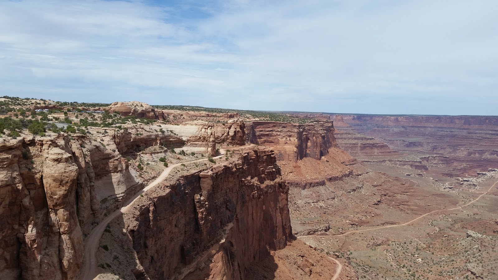
Islands is closest to Moab and offers the greatest
accessibility and has 20 miles of paved roads. It is a 6,080 ft elevation mesa
that overlooks the Green and Colorado Rivers. We took a short hike across from
the Visitors Center to an overlook that looked east to the Shafer Trail and the
Colorado River. We watched a short movie, Wilderness of Rock, and listened to a
short Ranger talk about the geology of the Park. Basically, the earth’s
uplifting created the Colorado Plateau and then the rivers carved two large canyons
while summer thunderstorms brought heavy rains that scoured the landscape
creating the buttes, fins, spires and arches. We took a short drive to the
trailhead parking lot and began the hike of the Neck Spring trail. This is a 5.8-mile loop hike that is the only
moderate hike in this section and was advertised as a 3 to 4-hour effort. It
took us a bit longer. The trail was largely under and on the side of the mesa.
There were a couple of springs along the trail, but we did not see any large animals.
Nor did we see many other people. Other than 3 groups that passed us early on
the trail, we did not see any other hikers. We passed some very weathered gear
and structures from the period when there was cattle ranching in the area Lots
of views of canyons and sandstone bowls.
We stopped for lunch along the trail. After lunch there was
one very steep part of the trail that required climbing over rock. The last
part of the trail was across flat rock with some juniper trees that ultimately
lead to a trail that paralleled the road. We were tired when we finished about
3:30. It did not seem to be excessively hot, but I felt depleted at the end.
We drove to the end of the mesa, and the road, to Grand View
Point. A short walk afforded spectacular panoramic views as we walked along the
canyon’s edge. A good place for a sunset view, but we were too early. Lots of
tourists here. Just below us was the White Rim trail, a 100-mile trial that
parallels the rivers and is used by cyclists for up to two-day trips. Beyond
the Trail we could see the Colorado River and beyond that the spires of the
Needles section.
We got back into the car and retraced our trip to the Mesa
Arch parking area. It was a short hike to the arch. This is a big solid arch
that affords great sunrise views. We were too late for that.
We left the Park about 5:00 and returned to the Inn about
6:00. We ate dinner at the Spoke on Center. OK food, but the milk shake was
terrific. Spent some time in the hot tub and charged up the car in the evening.


May 8 Canyonlands NP – Needles
The Needles forms the southeast corner of Canyonlands. It is
deservedly named for the colorful spires of Cedar Mesa sandstone that dominate
the area. To me, from some viewpoints that looked like the skyline of a major
city. After breakfast in the room we drove south out of Moab on Route 191 for
40 miles and then west on route 211 for 35 miles to the Needles Visitor
Center. Same movie in the Center so
after a short pit stop we drove off to the Cave Spring trailhead. This is a
short, 0.7-mile loop trail that was advertised as easy, but had some rough
terrain, two ladders and hard slickrock on the trail. We passed several alcoves
in the rock. One housed the remains of a historic cowboy camp and in two others
there were Indian pictographs. It was getting hot and it was striking how much
cooler it was in the alcoves. There was a lot of vegetation in the area from a
spring that we did not see. The ladders
required some scrambling, but when we got up to the slickrock there were
terrific views of the Needles.
We drove about 10 minutes to the Wooden Shoe Arch Overlook.
I really did look like a shoe.
We then drove further into the Park and stoped at rest area
for lunch. It was getting hot and very sunny and all the tables with umbrellas
were occupied. However, a couple invited us to sit with them. They were from Michigan
and were out west to assist a son moving to Denver. They had driven out here in
a small camper. They had parked their camper at the Visitor’s Center and had
ridden around the Park on bicycles. There was not much auto traffic on the park
roads, but there were no bicycle lanes and a very small shoulder.
After lunch we drove to the Slickrock trail head. It was
almost at the end of the road. This is an out and back .5-mile trail that leads
to a 2.0-mile loop. The trail offered several expansive, 360 degree views of
the Park including a view of Islands in the Sky and the confluence of the Green
and Colorado Rivers. Pretty impressive. Not many other hikers on this trail. It
took us about 3.0 hours.
At the end of the hike we drove to the Park Center and after
a pit stop, we drove back to Moab. We had dinner at The Blue Pig, a barbeque
restaurant with live music. The food was good as was the music, but the latter
was too loud. Another hot tub visit and charged up the car.


May 9th Arches
We got up and out of the Inn early and escaped the line at
the Park’s entrance. The main road entering the Park past the Visitor’s center provides
a pulse pounding entrance as the road makes numerous switchbacks as it climbs
the cliffs, initially of white sandstone and then red hued slickrock. Around
every turn I caught breathtaking views of rock formations, arches and sweeping
panoramas. However, notwithstanding our early start, the parking lot at the
trailhead for the Delicate Arch was almost full.
The 1.5-mile trail to the Arch started out gradually, but
soon began an ascent, first on a dirt trail and then broadening out to a
traverse of broad slickrock. For the first time during our trip we saw numerous
people on the trail. In one couple the guy was urging his female companion, who
was obviously scared of the ascent, up the rockface. She was able to go forward
a little more, but ultimately turned around. Toward the end the trail narrowed and wound
its way around a steep drop off. As we approached the Arch we could view it
through another arch. I met a French-Canadian couple there from Quebec and we had
a nice chat and took pictures of each other.
As you come around the final bend and finally view the Arch
you get a magnificent view of the structure. My National Geographic Secrets of
the National Parks Guidebook said that going to Arches without seeing the
Delicate Arch is like going to the Louvre without seeing the Mona Lisa. For
once, it was not hyperbole. After taking
in the view for a bit I continued and walked under the Arch. It is perched on
the precipitous edge of a monumental cliff. Theer was a short line to get a
solo picture under the Arch. Lots of different languages spoken here.
The walk back down was easier, but hotter and we passed even
more people hiking up. On the way down, we took a detour to the Wolfe Ranch and
Ute Petroglyphs, but not before sharp encounter with a man who was tramping off
the trail in front of a sign that specifically said not to do that and a sharp
rebuke from his wife for us to mind our own business. The Utes, who knew better
than to live here, but semi-annually passed through, left a petroglyph panel of
horses and dogs that date back to the mid-1700s. The Wolfe Ranch is a rough
shod, one room cabin in which the Wolfe family lived in at the turn of the 20th
century. It is the Park’s only evidence of permanent habitation, and in the
case of the Wolfe family, they gave up after a decade. A very unaccommodating
land for humans.
We drove almost to the end of the Arches Scenic Drive and
parked to hike to the Sand Dune and Broken Arches. The former is a short walk
from the road and is observed by squeezing through a narrow passageway. The ground
is all fine sand here.
We then took a 1-mile hike across a grassy meadow which was
populated with lots of colorful wildflowers to Broken Arch. If we had followed the trail through the Arch
it would have taken us to Devil’s Garden, but it was getting very hot so as
planned we turned around and retreated to the Inn to wait out the afternoon
heat.
I took an afternoon swim in the pool and a 7:00 we drove back
to Arches. We had crossed the Colorado River bridge at the north end of town
several times by then, but this time we turned right and drove along the river.
Very scenic drive with cliffs on one side and the lazy river on the other.
We drove out to Balanced Rock and hiked in a short distance
to climb up into an arch to watch the sunset. Nice views and colors, but I have
seen prettier on the CA. coast.
Returned to the Moab brewery for dinner. The beer was again
good, but the hamburger looked better than it tasted.


May 10th Drive Back
Nothing special. We got out about 9:15 and retraced our inbound
trip. Stopped at the same rest stop for a break and ate lunch in Draper. Dropped
our friend off at the airport and returned home.
No comments:
Post a Comment